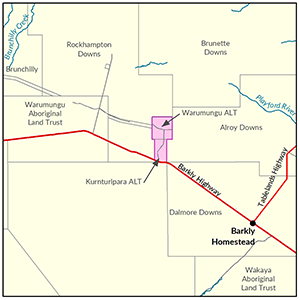
Kurnturlpara and Warumungu Aborignal Land Trusts
In 2015-16 the Department of Environment and Environment and Natural Resources undertook a soil and land suitability assessment on lands owned by Kurnturlpara and Warumungu Aboriginal Land trusts, locally known as Frewena.
Of the 17,232ha surveyed, 2,490ha were identified as moderate capability land and approximately 14,450ha as land of marginal capability.
An additional 400ha of the moderate capability land was further assessed with approximately 118ha identified as suitable for irrigated agricultural.
The Kurnturlpara and Warumungu Aboriginal Land overlay two main aquifers within the Georgina Basin.
The 2019 Georgina Basin Groundwater Assessment: Daly Water to Tennant Creek identifies the Gum Ridge Formation as a regional scale fractured and karstic aquifer and the Anthony Lagoon Formation, which overlies the Gum Ridge Formation, as numerous stratified intermediate scale, fractured and karstic aquifers.
The Gum Ridge Formation has the best potential for irrigation supplies due to its potential for high yields, shallower bores while the Anthony Lagoon Formation has potential for small-scale irrigation supplies. Groundwaters in the Basin range from fresh to saline but are generally fresher and more suitable for irrigation on the Basin margins. Detailed investigations of the suitability of the local water quality on soil types and the crops to be irrigated are recommended before any major irrigation projects are proceeded with.
The Kurnturlpara and Warumungu Aboriginal Lands are not within a Water Control District or subject to a Water Allocation Plan. Therefore production bores within these lands do not require a bore construction permit and only require an extraction license if they are equipped to supply >15l/s.

View a larger version of the Kurnturlpara and Warumungu Aboriginal Land Trusts locality map.
Soil and land
The following report and maps document the soil and land factors likely to impact irrigated agricultural development and highlight the crops most suited to the study area.
- Read the report on the Territory Stories website.
- View the maps (pdf).
- View the spatial data package.
- View the metadata.
- View the survey location on NR Maps.
Water
The 'Georgina Basin Groundwater Assessment: Daly Waters to Tennant Creek report' is a technical report. It describes the hydrogeological characteristics of the Gum Ridge and Anthony Lagoon formations within the Georgina Basin.
The report estimates water availability, bore yield and groundwater quality.
- Read the report on the Territory Stories website.
- View the Georgina Basin survey location on NR Maps.
Contact
For further information contact rangelands@nt.gov.au
Give feedback about this page.
Share this page:
URL copied!